Find accommodation
Logo Südtirol
skip to content
Bicycle Rides Bicycle Rides  · South of South Tyrol Open

Altrei/Anterivo-Malga Monte Corno-Altrei/Anterivo

Responsible for this content
Südtirols Süden
  • Anterivo/Altrei
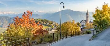
    Anterivo/Altrei
    Photo: Marketing Siegfried Unterkircher, Südtirols Süden
Map / Altrei/Anterivo-Malga Monte Corno-Altrei/Anterivo

Selected alternatives for you
    Scenic mountain bike tour from Altrei/Anterivo via Ziss-Sattel to Horn Alm at 1,710 metres. Enjoy peaceful forest trails, beautiful mountain views and a rewarding descent.
    Open
    Moderate
    Distance 14.2 km
    1:48 h
    568 m
    568 m
    1,707 m
    1,179 m

    This varied mountain bike tour takes you from Altrei through the idyllic forests of Trudner Horn Nature Park to Horn Alm at 1,710 metres above sea level. Along the way, enjoy pleasant forest roads, beautiful mountain scenery and impressive views of the surrounding peaks.

    The tour starts at the town hall square in Altrei. From here, cycle through the village towards Hotel Waldheim before turning left towards Pra'del Manz. Follow well-maintained forest roads steadily uphill to Ziss-Sattel and continue to Horn Alm, the highest point of the tour. Here, you can enjoy a relaxing break and take in the stunning mountain views.

    After a well-deserved rest, return to Ziss-Sattel, where a pleasant downhill ride through shady forests takes you back to the starting point in the village centre of Altrei.

    Tour Nr. 8

    Author’s recommendation

    • The panoramic views around Horn Alm offer impressive sights of the surrounding mountains and valleys.
    • Before or after the hike, it is worth taking a walk through the small mountain village with its traditional architecture.
    Responsible for this content
    Südtirols Süden 
    Difficulty
    Moderate
    Overall difficulty
    Moderate

    Derived from the technical difficulty and the stamina requirements.

    Experience
    Landscape
    Highest point
    1,707 m
    Lowest point
    1,179 m
    Best time of year
    Jan
    Feb
    Mar
    Apr
    May
    Jun
    Jul
    Aug
    Sep
    Oct
    Nov
    Dec

    Track types

    Show elevation profile

    Safety information

    Please make sure to follow traffic rules and check the weather conditions before the tour.

    Roadbook

    The tour starts at the Town Hall Square in Altrei. Passing through the village, the route continues towards Waldheim and then to Pra’ del Manz. The route follows pleasant forest roads with a steady climb to Ziss Pass and then to Horn Alm, the highest point of the tour. After a break, the route returns to Ziss Pass and descends through the forest back to Altrei. The route is marked with number 8.
    Rest stop
    Tip
    Nearby
    Top Partner
    Waypoint
    Start point
    End point
    Low point
    High point
    Forecast
    Today {low} to {high} and {precipitation} of {precipitation_type}
    show {x} more
    Photo
    Video
    Charge E-Car in Altrei/Anterivo
    Rifugio Malga Corno
    Parish Church in Altrei/Anterivo
    Bibliothek Altrei

    Public transport

     To reach Altrei, take the train from Bolzano train station to Neumarkt–Tramin train station. From there, continue with bus line 144 from the station to Altrei. The stop to get off at is “Zentrum”.

    Please check in advance whether bicycles can be taken on the bus.

    Get Timetable to destination

    to
    Altrei/Anterivo-Malga Monte Corno-Altrei/Anterivo

    Directions

    Altrei can be reached via the A22 Brenner motorway. From the Neumarkt–Auer–Tramin exit, the route continues through Auer and Montan to Altrei.

    Parking

    At the public car park in Altrei.

    Coordinates

    DD
    46.277791, 11.366328
    DMS
    46°16'40.0"N 11°21'58.8"E
    UTM
    32T 682309 5127634
    w3w 
    ///jostles.records.praised
    Get there by train, car, bike, or on foot!

    Equipment

    The recommended equipment includes a repair kit, sufficient water, sun protection, and a roadworthy bicycle.

    Similar routes nearby

    • Altrei/Antrevio Panorama Tour
    • Trodena-Connection Cycle Route Adige
    • By bike from gentle vineyards to the majestic Dolomites – from Egna to Castelrotto
    • Dolomites Road Bike Challenge
    • Kalterer See
    • Mitterberg Round
    • Castelfeder – Trient – Garda
     These suggestions were generated by our system
    Status
    Open
    Difficulty
    Moderate
    Overall difficulty
    Moderate

    Derived from the technical difficulty and the stamina requirements.

    Distance
    14.2 km
    Duration
    1:48 h
    Ascent
    568 m
    Descent
    568 m
    Highest point
    1,707 m
    Lowest point
    1,179 m
    eBike Refreshment stops available Round trip

    Statistics

    • Content
    • Show images Hide images
    Features
    Maps and trails
    Nothing selected - click and drag in the elevation profile to zoom
    Distance
    Duration
    Ascent
    Descent
    Elevation profile
    ✖
    jenesien-herbst-4-tv-jenesien-michael-guggenberg
    Jenesien newsletter

    Jenesien, always close even from afar – with our newsletter!

    Sign up now and get the latest information about our gentle holiday region delivered straight to your home.

    We look forward to having you with us!


    Sign up now!