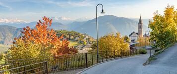
Hiking trail
· South of South Tyrol
Open
Anterivo- Monte Corno- Anterivo
Responsible for this content
Südtirols Süden
Südtirols Süden
-
 Malga CornoPhoto: Jessica Iori, Südtirols Süden
Selected alternatives for you
Challenging circular hike from Altrei/Anterivo via Horn Alm to Trudner Horn, featuring sweeping mountain views, peaceful wetlands and beautiful larch forests.
Open
Difficult
Distance 16.9 km
5:08 h
736 m
736 m
1,743 m
1,177 m
This varied circular hike takes you from Altrei through the beautiful natural landscapes of Trudner Horn Nature Park to the welcoming Horn Alm. Along the way, you'll discover shady forests, extensive larch meadows, picturesque alpine huts and peaceful wetlands.
Starting in Altrei, you initially follow a forest road through shady woodland before the route narrows into a trail. Passing charming alpine huts and small wetlands, the path continues uphill through light-filled larch meadows. Once you reach the higher part of the route, you'll pass the idyllic Weißensee and Schwarzensee lakes before arriving at Horn Alm, situated at 1,710 metres above sea level. Here, you'll be rewarded with breathtaking views of the Val di Fiemme Alps.
The welcoming Horn Alm is the perfect place for a well-deserved break. Afterwards, descend towards Ziss-Sattel and continue through shady spruce and fir forests. Passing the historic lime kilns, the trail eventually leads you back to Altrei.
Starting in Altrei, you initially follow a forest road through shady woodland before the route narrows into a trail. Passing charming alpine huts and small wetlands, the path continues uphill through light-filled larch meadows. Once you reach the higher part of the route, you'll pass the idyllic Weißensee and Schwarzensee lakes before arriving at Horn Alm, situated at 1,710 metres above sea level. Here, you'll be rewarded with breathtaking views of the Val di Fiemme Alps.
The welcoming Horn Alm is the perfect place for a well-deserved break. Afterwards, descend towards Ziss-Sattel and continue through shady spruce and fir forests. Passing the historic lime kilns, the trail eventually leads you back to Altrei.
Author’s recommendation
Start early for the best views and peaceful atmosphere.
The summit is especially beautiful at sunset.
Combine the hike with a stop at Hornalm.
The summit is especially beautiful at sunset.
Combine the hike with a stop at Hornalm.
Responsible for this content
Südtirols Süden
Südtirols Süden
Difficulty
Difficult
Overall difficulty
Difficult
Derived from the technical difficulty and the stamina requirements.
Experience
Landscape
Highest point
1,743 m
Lowest point
1,177 m
Best time of year
Jan
Feb
Mar
Apr
May
Jun
Jul
Aug
Sep
Oct
Nov
Dec
Track types
Show elevation profileRest stops
Coop Anterivo/AltreiChurch day in Altrei
Coop Anterivo/Altrei
Safety information
Check weather conditions before starting.Weather can change quickly at higher elevations.
Stay on marked trails.
Carry a charged phone and first-aid kit.
Avoid the hike during thunderstorms.
Roadbook
The hike starts in Altrei and climbs through forests and mountain meadows towards Hornalm. From there, the trail continues to the summit of Trudner Horn (1,781 m). The summit offers a magnificent 360° view of the Dolomites, Lagorai range and the surrounding Alps. The descent follows marked trails back to Altrei.
Rest stop
Nearby
Top Partner
Waypoint
Start point
End point
Low point
High point
Forecast
Today {low} to {high} and {precipitation} of {precipitation_type}
show {x} more
Photo
Video
Charge E-Car in Altrei/AnterivoCharge E-Car in Altrei/Anterivo
Rifugio Malga Corno
Parish Church in Altrei/Anterivo
Bibliothek Altrei
NK Nordischer Kreis
Festplatz Altrei
Coop Anterivo/Altrei
Church day in Altrei
Coop Anterivo/Altrei
Public transport
Train to Auer/Ora.Bus connection to Altrei.
Check seasonal timetables.
Get Timetable to destination
Anterivo- Monte Corno- Anterivo
Directions
Leave the A22 motorway at Neumarkt–Auer.Continue via Montan and San Lugano Pass to Altrei.
The hike starts in the village centre.
Parking
Public parking areas in Altrei.Additional hiking parking areas near the village.
Coordinates
DD
46.278582, 11.366417
DMS
46°16'42.9"N 11°21'59.1"E
UTM
32T 682313 5127722
w3w
///locater.evaporate.sniffle
Get there by train, car, bike, or on foot!
Equipment
Hiking bootsLayered clothing
Rain jacket
Sun protection
Enough water
Hiking poles recommended
Status
Open
Difficulty
Difficult
Overall difficulty
Difficult
Derived from the technical difficulty and the stamina requirements.
Distance
16.9 km
Duration
5:08 h
Ascent
736 m
Descent
736 m
Highest point
1,743 m
Lowest point
1,177 m
Statistics
Maps and trails
Nothing selected - click and drag in the elevation profile to zoom
Distance
Duration
Ascent
Descent


 Find accommodation