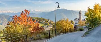
Hiking trail
· South of South Tyrol
Open
Hiking Trail Nr. 15: Entiklar- Margreid-Kurtinig
Responsible for this content
Südtirols Süden
Südtirols Süden
-
 BiotopPhoto: Simone Bellutti, Südtirols Süden
Selected alternatives for you
The 3D Trail Entiklar–Margreid–Kurtinig is an easy, family-friendly walk suitable for strollers, leading through vineyards, orchards, and natural biotopes with diverse wildlife.
Open
Easy
Distance 4.8 km
1:12 h
3 m
21 m
232 m
208 m
A relaxing walk for the whole family.
The 3D Trail connects the villages of Entiklar, Margreid and Kurtinig, leading through a varied landscape of blossoming orchards, expansive vineyards and idyllic biotopes.
The easy, almost completely flat route is also suitable for pushchairs and invites visitors to enjoy nature at a leisurely pace. There is plenty to discover along the way: the biotopes are home to various animal species which, with a little luck, can be spotted along the route. The diverse plant life and magnificent views of the surrounding landscape also make this trail a truly special experience.
Whether exploring with little adventurers, enjoying a relaxed family outing or simply taking a leisurely walk in the fresh air, the 3D Trail offers a wonderful nature experience for visitors of all ages.
The walk can be started in either Margreid or Kurtinig. Both villages are very well connected by public transport, making the trail an ideal choice for anyone who prefers to travel without a car.
The 3D Trail connects the villages of Entiklar, Margreid and Kurtinig, leading through a varied landscape of blossoming orchards, expansive vineyards and idyllic biotopes.
The easy, almost completely flat route is also suitable for pushchairs and invites visitors to enjoy nature at a leisurely pace. There is plenty to discover along the way: the biotopes are home to various animal species which, with a little luck, can be spotted along the route. The diverse plant life and magnificent views of the surrounding landscape also make this trail a truly special experience.
Whether exploring with little adventurers, enjoying a relaxed family outing or simply taking a leisurely walk in the fresh air, the 3D Trail offers a wonderful nature experience for visitors of all ages.
The walk can be started in either Margreid or Kurtinig. Both villages are very well connected by public transport, making the trail an ideal choice for anyone who prefers to travel without a car.
Author’s recommendation
Visit to the Tiefenbrunner winery and the Fairy Tale Garden in Entiklar.
Responsible for this content
Südtirols Süden
Südtirols Süden
Difficulty
Easy
Overall difficulty
Easy
Derived from the technical difficulty and the stamina requirements.
Experience
Landscape
Highest point
232 m
Lowest point
208 m
Best time of year
Jan
Feb
Mar
Apr
May
Jun
Jul
Aug
Sep
Oct
Nov
Dec
Track types
Show elevation profileSafety information
It is recommended to bring sun protection such as sunscreen and a hat to protect yourself from the sun, and to check the weather forecast in advance.Roadbook
The walk starts at the Niclara playground and follows the wine-themed educational trail. At the junction in the village centre of Margreid, continue along the wine educational trail no. 15 towards Kurtinig an der Weinstraße. The route crosses the cultural landscape of the South Tyrolean Lowlands, passing vineyards and biotopes, until reaching the village centre of Kurtinig an der Weinstraße.
Rest stop
Nearby
Top Partner
Waypoint
Start point
End point
Low point
High point
Forecast
Today {low} to {high} and {precipitation} of {precipitation_type}
show {x} more
Photo
Video
Margreider LeitenwegChurch of San Gertrude
Old Grapevine
Parking lot school Margreid a.d.W.
Church of San Martino
Public transport
The journey starts by train from Bozen to Margreid. At Margreid train station, you need to change to bus line 124, whose stop is located directly next to the station. The bus continues to the “Margreid an der Weinstraße” stop, from where the hike can begin.Get Timetable to destination
Hiking Trail Nr. 15: Entiklar- Margreid-Kurtinig
Directions
Take the Neumarkt-Auer exit from the A22 motorway. From there, Margreid can be reached in about 10 minutes.Parking
At the public parking areas in Entiklar.Coordinates
DD
46.287487, 11.209802
DMS
46°17'15.0"N 11°12'35.3"E
UTM
32T 670220 5128363
w3w
///failsafe.hailed.loosen
Get there by train, car, bike, or on foot!
Equipment
The appropriate equipment includes comfortable and sturdy hiking shoes, weather-appropriate clothing, enough water, a small snack, sun protection, a backpack for personal items and, if needed, hiking poles or a small first-aid kit.Status
Open
Difficulty
Easy
Overall difficulty
Easy
Derived from the technical difficulty and the stamina requirements.
Distance
4.8 km
Duration
1:12 h
Ascent
3 m
Descent
21 m
Highest point
232 m
Lowest point
208 m
Statistics
Maps and trails
Nothing selected - click and drag in the elevation profile to zoom
Distance
Duration
Ascent
Descent


 Find accommodation