Hiking trail
· South of South Tyrol
Open
Muletrack Altrei/Anterivo - Truden/Trodena
Südtirols Süden
-
 Langes MoosPhoto: Südtirols Süden
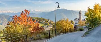
The historic mule track connects the two mountain villages of Altrei and Truden, leading you through the beautiful natural landscapes of Trudner Horn Nature Park. Along the way, discover peaceful forests, protected wetlands, traditional mountain farms and lovely views of the surrounding mountains.
The hike starts at the town hall square in Altrei. From here, the trail leads through meadows and forests towards Krabes Alm, where you can enjoy a relaxing refreshment stop. Alternatively, you can walk directly through the Langes Moos biotope, known for its fascinating wetland landscape.
Continue past Riegenschupf, Peraschupf and Pinterschupfe until you reach the picturesque Runggan farm. Following the Truden Legends Trail, you eventually arrive in the village centre of Truden/Trodena.
As this is a one-way hike, you can return to Altrei/Anterivo by public transport.
Author’s recommendation
Südtirols Süden
Derived from the technical difficulty and the stamina requirements.
Track types
Show elevation profileSafety information
The route partly follows narrow forest paths and historic trails. Some sections can become slippery in wet conditions. Pay attention to suitable footwear and weather conditions.Roadbook
Starting point: Town Hall Square, Altrei
Route: The Mule Track Trail begins at the hiking starting point at Town Hall Square in Altrei. It first follows Hiking Trail No. 5 and then continues along Trail No. 6 towards Truden. The route can either be taken via Krabes Alm or directly through the Langes Moos biotope. The trail continues across Riegenschupf, Peraschupf and Pinterschupfe to Rungganöhof farm. From there, the route follows Legend Trail No. 8 to the hiking starting point in the centre of Truden.
Refreshment stops along the route: Krabes Alm (open from May until early November), Hotel Schönwies, inns and cafés in Altrei and Truden.
Highlights: Trudner Horn Nature Park, Langes Moos biotope, Krabes Alm, Riegenschupf, Peraschupf, Pinterschupfe, Rungganöhof farm, woodland and moor landscapes, Truden Legend Trail.
Drinking water fountain Altrei Pichl
Krabes Alm
Charge E-Car in Truden i.N.
Drinking water fountain Truden i.N. Kirchplatz
Public transport
Take the train to Neumarkt/Auer. From there, bus connections are available to Altrei. Return connections from Truden towards Neumarkt/Auer are also available.Get Timetable to destination
Directions
Take the A22 motorway and exit at Neumarkt/Auer. Continue via Montan, Kaltenbrunn and Truden to Altrei.Parking
Public parking is available at the town hall square in Altrei.Coordinates
Equipment
Hiking boots with good grip, weather-appropriate clothing, sun protection, sufficient water and hiking poles if needed.Derived from the technical difficulty and the stamina requirements.
Statistics


 Find accommodation