Hiking trail
· South of South Tyrol
Open
Buchholz trail
Responsible for this content
Südtirols Süden
Südtirols Süden
-
 Giardino delle sculturePhoto: TV Trudner Horn / TG Castelfeder / TV Aldein / Thomas Monsorno, Südtirols Süden
Selected alternatives for you
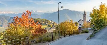
Easy circular walk around the charming mountain village of Buchholz. Forests, meadows and the Sculpture Trail make this an enjoyable family-friendly hike.
Open
Easy
Distance 2.3 km
0:43 h
119 m
119 m
567 m
460 m
The Pochi/Buchholz circular walk is a pleasant hike through the countryside surrounding the small mountain village of Pochi, above Salorno. The easy route is also suitable for families and combines nature, art and culture.
The hike starts in the village centre of Pochi. From here, the trail initially follows the Dürer Trail to the Niedere-Höfe-Weg. Along the way, you can enjoy beautiful views of the varied landscape surrounding the mountain village.
The route then continues to the sculpture garden, where numerous artworks made from different materials are displayed in a natural setting. From here, the trail leads back through the village to the starting point.
The hike starts in the village centre of Pochi. From here, the trail initially follows the Dürer Trail to the Niedere-Höfe-Weg. Along the way, you can enjoy beautiful views of the varied landscape surrounding the mountain village.
The route then continues to the sculpture garden, where numerous artworks made from different materials are displayed in a natural setting. From here, the trail leads back through the village to the starting point.
Author’s recommendation
Perfect for families with children.
Don't miss the Sculpture Trail.
A great option for a relaxed afternoon walk.
Don't miss the Sculpture Trail.
A great option for a relaxed afternoon walk.
Responsible for this content
Südtirols Süden
Südtirols Süden
Difficulty
Easy
Overall difficulty
Easy
Derived from the technical difficulty and the stamina requirements.
Experience
Landscape
Highest point
567 m
Lowest point
460 m
Best time of year
Jan
Feb
Mar
Apr
May
Jun
Jul
Aug
Sep
Oct
Nov
Dec
Track types
Show elevation profileSafety information
Be careful on wet paths after rain.Stay on marked trails.
Respect nature and private property.
Roadbook
The circular trail starts in the village centre and follows parts of the Dürer Trail and the Sculpture Trail through forests and meadows. Scenic viewpoints and artistic installations accompany hikers before returning to the starting point.
Rest stop
Nearby
Top Partner
Waypoint
Start point
End point
Low point
High point
Forecast
Today {low} to {high} and {precipitation} of {precipitation_type}
show {x} more
Photo
Video
Parish church S. OrsolaSculpture garden
Parish church S. Orsola
E-bike charging station in Buchholz/Pochi
Public transport
Train to Salurn.Bus connection to Buchholz.
Get Timetable to destination
Buchholz trail
Directions
Exit the A22 motorway at Neumarkt–Auer.Continue to Salurn and Buchholz.
Parking
Public parking in the village centre.Coordinates
DD
46.246360, 11.241162
DMS
46°14'46.9"N 11°14'28.2"E
UTM
32T 672764 5123861
w3w
///fling.dummy.sports
Get there by train, car, bike, or on foot!
Equipment
Comfortable walking shoesWater
Sun protection
Weather-appropriate clothing
Status
Open
Difficulty
Easy
Overall difficulty
Easy
Derived from the technical difficulty and the stamina requirements.
Distance
2.3 km
Duration
0:43 h
Ascent
119 m
Descent
119 m
Highest point
567 m
Lowest point
460 m
Statistics
Maps and trails
Nothing selected - click and drag in the elevation profile to zoom
Distance
Duration
Ascent
Descent


 Find accommodation