Road biking
· South of South Tyrol
Open
Roadbike: Valle di Cembra
Responsible for this content
Südtirols Süden
Südtirols Süden
-
 BikePhoto: Tourismusverein Südtiroler Unterland, Südtirols Süden
Selected alternatives for you
Scenic circular road cycling tour from Margreid/Magrè through the Adige Valley and Val di Cembra to Val di Fiemme.
Open
Moderate
Distance 99.8 km
5:29 h
1,326 m
1,326 m
1,102 m
200 m
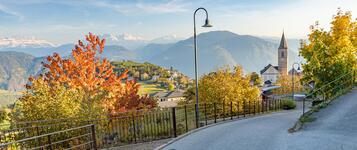
This challenging circular road cycling tour takes you from Margreid through South Tyrol's southern Adige Valley into neighbouring Trentino. The route combines the apple orchards and vineyards of the Adige Valley with the varied mountain landscapes of Val di Cembra and Val di Fiemme.
The tour starts in Margreid. From here, the route initially leads through apple orchards via Kurtinig/Cortina to Salurn/Salorno, before continuing south along the Adige Cycle Route. Shortly after Nave San Rocco, the route leaves the cycle path and heads through Lavis into Val di Cembra.
This is where the more challenging part of the tour begins. Winding mountain roads lead uphill through Val di Cembra towards Cavalese. Along the way, beautiful views of the surrounding mountains and the landscapes of Trentino accompany the climb.
From Cavalese, the route continues to San Lugano. A descent then takes you to Auer/Ora, before cycling through the apple orchards of South Tyrol's southern Adige Valley back to Margreid/Magrè.
A varied circular tour for experienced road cyclists who enjoy long climbs and scenic mountain roads.
The tour starts in Margreid. From here, the route initially leads through apple orchards via Kurtinig/Cortina to Salurn/Salorno, before continuing south along the Adige Cycle Route. Shortly after Nave San Rocco, the route leaves the cycle path and heads through Lavis into Val di Cembra.
This is where the more challenging part of the tour begins. Winding mountain roads lead uphill through Val di Cembra towards Cavalese. Along the way, beautiful views of the surrounding mountains and the landscapes of Trentino accompany the climb.
From Cavalese, the route continues to San Lugano. A descent then takes you to Auer/Ora, before cycling through the apple orchards of South Tyrol's southern Adige Valley back to Margreid/Magrè.
A varied circular tour for experienced road cyclists who enjoy long climbs and scenic mountain roads.
Author’s recommendation
- Enjoy the nature and take some breaks.
- Visit the old village centre with the traditional “Case Romane” from the 16th century.
Responsible for this content
Südtirols Süden
Südtirols Süden
Difficulty
Moderate
Overall difficulty
Moderate
Derived from the technical difficulty and the stamina requirements.
Experience
Landscape
Highest point
1,102 m
Lowest point
200 m
Best time of year
Jan
Feb
Mar
Apr
May
Jun
Jul
Aug
Sep
Oct
Nov
Dec
Track types
Show elevation profileSafety information
Roadbook
The tour starts at the kindergarten in Margreid a. d. W. From there, follow the South Tyrolean Wine Road towards Kurtinig a. d. W. The route then continues along the Adige River towards Pfatten. The river is crossed twice before reaching Nave San Rocco. From there, continue to Lavis and then uphill to Cembra. The route passes through the varied landscape of Trudner Horn Nature Park i. N. and continues via Montan a.d.W. to Auer. Finally, the "Tramin Road" leads back to Margreid a. d. W.
Rest stop
Nearby
Top Partner
Waypoint
Start point
End point
Low point
High point
Forecast
Today {low} to {high} and {precipitation} of {precipitation_type}
show {x} more
Photo
Video
Church of San GertrudeStazio
Fiume Adige
San Michele
Maso Rover
Zambel panoramic viewpoint
Punto panoramico Lavis
Biotopo di Brozin
Brozin Biotope
Trenches in San Lugano
Passo di San Lugano
Gschachnes (Braitohaus)
Parking lot school Margreid a.d.W.
Old Grapevine
Margreider Leitenweg
Public transport
By train from Bolzano to Margreid-Kurtatsch train station. From there, take bus line 124 to Margreid and get off at the “Margreid” bus stop.Please check in advance whether bicycles can be taken on the bus.
Get Timetable to destination
Roadbike: Valle di Cembra
Directions
The destination can be reached via the A22 Brenner Motorway, taking the Neumarkt–Auer–Tramin exit, from where Margreid a.d.W. is just a few minutes away by car.Parking
At the public car park in Margreid a.d.W., next to the Marienkapelle.Coordinates
DD
46.286963, 11.212504
DMS
46°17'13.1"N 11°12'45.0"E
UTM
32T 670429 5128311
w3w
///warming.lifter.consents
Get there by train, car, bike, or on foot!
Equipment
Please make sure to carry enough water, sun protection, and a roadworthy bicycle.Status
Open
Difficulty
Moderate
Overall difficulty
Moderate
Derived from the technical difficulty and the stamina requirements.
Distance
99.8 km
Duration
5:29 h
Ascent
1,326 m
Descent
1,326 m
Highest point
1,102 m
Lowest point
200 m
Statistics
Maps and trails
Nothing selected - click and drag in the elevation profile to zoom
Distance
Duration
Ascent
Descent


 Find accommodation