Winter hiking
· South of South Tyrol
Open
Apple Trail Kurtatsch - Tramin
Südtirols Süden
-
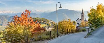
 ApfelwegPhoto: Dietmar Mitterer Zublasing, Südtirols Süden
During a beautiful and scenic walk through the apple orchards, you can discover a wealth of interesting information about the characteristics of the growing area and South Tyrolean apples.
At 16 stations, information boards in three languages provide insights into the diversity of apple varieties, sustainable farming, modern storage methods and the work of farmers.
At 5 selected stations, the trail becomes audible: exciting podcast episodes accompany you directly on site. Simply scan the QR code and discover the world of apples through audio.
Nature, enjoyment and knowledge — this easy-to-walk route is suitable for leisurely walkers, school classes and the whole family. The trail is suitable for pushchairs only from the section at the foot of the Millastiege steps.
Route description
From the main square, walk past the pilgrimage church of St. Vigilius towards the entrance to the village, where you cross the Wine Road and descend to the “Millabach”. Cross the stream over the covered bridge and follow the “Millastiege” steps down into the valley. Along the boundary between fruit-growing and wine-growing areas, walk northwards, always following the signs along the Brenntalweg towards Tramin.
Starting point: Main square in Kurtatsch or the village centre of Tramin.
Refreshment options along the route: Schwarz Adler Restaurant, Weinstraße Pizzeria, inns, cafés, traditional farm taverns and wineries in Kurtatsch and Tramin.
Along the way, cosy spots invite you to stop and relax, with impressive panoramic views over South Tyrol’s southern lowlands appearing time and again.
The Apple Trail can be walked from Kurtatsch to Tramin or in the opposite direction, according to your preference.
Author’s recommendation
- Explore the informative stations along the Apple Trail
- Enjoy engaging podcasts along the route
- Start the hike early in the morning or late in the afternoon
- Avoid the strong midday sun
Südtirols Süden
Derived from the technical difficulty and the stamina requirements.
Track types
Show elevation profileSafety information
We count on your cooperation and considerate behaviour to help protect nature, show appreciation to the landowners, and ensure a positive experience for everyone on this special hiking trail.Roadbook
Starting point: Kurtatsch Main Square or Tramin village centre
Route: The Apple Trail connects Kurtatsch and Tramin and can be walked from either village. From Kurtatsch, the route initially passes the main square and the Pilgrimage Church of St. Vigilius before reaching the village entrance. After crossing the South Tyrolean Wine Road, the trail descends to the Milla Stream, crosses the covered wooden bridge and follows the Millastiege down into the valley. Along the natural boundary between fruit-growing and wine-growing areas, the trail follows the Brenntalweg to Tramin. The Apple Trail can also be walked in the opposite direction.
Refreshment stops along the route: Schwarz Adler Restaurant, Weinstraße Pizzeria, inns, cafés, traditional wine taverns and wineries in Kurtatsch and Tramin.
Highlights: Extensive apple orchards and vineyards, Milla Stream, covered wooden bridge, 16 information stations about South Tyrolean apples, podcast stations along the route and views over the South Tyrolean Lowlands.
Drinking water fontain Hauptplatz Kurtatsch
Freienfeld Menhir
Ansitz Freienfeld
Church of St. Vigilius
Museum of People through Time
Church St. Valentin
Public transport
For the return journey, you can either take the quiet panoramic road via Rungg (abouta 1 hour walk) or conveniently return by public transport using bus lines 122 or 130.
“Mindelheim” bus station in Tramin or “Im Feld” bus stop in Kurtatsch.
You can find all current bus timetables here: https://www.suedtirolmobil.info/en/#/
Get Timetable to destination
Directions
Kurtatsch and Tramin can be reached via the A22 motorway, taking the Neumarkt–Auer exit. From there, follow the South Tyrolean Wine Road towards Tramin or Kurtatsch.Parking
At the entrance to the village, in the center of Kurtatsch, or at the Mindelheimer parking lot in Tramin.Coordinates
Equipment
One should ensure adequate sun protection, carry enough water, and wear comfortable, weather-appropriate clothing.Derived from the technical difficulty and the stamina requirements.
Statistics


 Find accommodation