
 Bicycle Rides
· South of South Tyrol
Open
Dolomites Road Bike Challenge
Responsible for this content
Südtirols Süden
Südtirols Süden
-
 BikerPhoto: Südtirols Süden
Selected alternatives for you
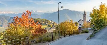
Challenging circular road cycling tour from Neumarkt/Egna through the Dolomites, crossing Sellajoch and Pordoijoch, with spectacular mountain panoramas.
Open
Difficult
Distance 154.3 km
12:24 h
2,871 m
2,871 m
2,244 m
221 m
This challenging circular road cycling tour starts in Neumarkt and takes you through the impressive mountain landscapes of the Dolomites. Over approximately 154 kilometres, you can expect demanding climbs, winding mountain pass roads and wonderful views of the surrounding peaks.
From Neumarkt, the route initially follows the Adige Valley to Bolzano before climbing towards Kastelruth/Castelrotto and Val Gardena. Surrounded by imposing Dolomite peaks, the route continues over Sellajoch/Passo Sella and Pordoijoch/Passo Pordoi. The impressive rock formations and sweeping mountain panoramas make this section particularly memorable.
The tour then leads through Val di Fassa and continues into Val di Fiemme. From there, the route passes through San Lugano and Truden/Trodena before returning to Neumarkt.
With its long climbs, challenging mountain pass roads and varied descents, this circular tour is ideal for experienced road cyclists with excellent fitness who want to explore the Dolomites on two wheels.
Author’s recommendation
Visit the St. Katharina Church and traditional wooden farmhouses in Corvara, and discover authentic woodcarving workshops in St. Ulrich/Ortisei.
Responsible for this content
Südtirols Süden
Südtirols Süden
Difficulty
Difficult
Overall difficulty
Difficult
Derived from the technical difficulty and the stamina requirements.
Experience
Landscape
Highest point
2,244 m
Lowest point
221 m
Best time of year
Jan
Feb
Mar
Apr
May
Jun
Jul
Aug
Sep
Oct
Nov
Dec
Track types
Show elevation profileSafety information
Only suitable for experienced cyclists. Always wear a helmet, ride carefully, and watch for changing weather conditions.Roadbook
The tour starts in Auer/Ora and climbs through the peaceful Fiemme Valley to the scenic San-Lugano-Pass/Passo di San Lugano. Through Cavalese, the route continues to Canazei, surrounded by towering peaks. From there, the classic route crosses the Pordoijoch/Passo Pordoi, through Arabba, Campolongopass/Passo Campolongo, Corvara, and over the Grödner Joch/Passo Gardena to St. Ulrich/Ortisei. The shorter option leads over the Sellajoch/Passo Sella straight to Wolkenstein/Selva and St. Ulrich/Ortisei. Both return to Auer/Ora via Kastelruth/Castelrotto, Seis/Siusi and Völs/Fiè – a fitting finale to this unforgettable ride.
Rest stop
Nearby
Top Partner
Waypoint
Start point
End point
Low point
High point
Forecast
Today {low} to {high} and {precipitation} of {precipitation_type}
show {x} more
Photo
Video
Freizeitzentrum Schwarzenbach in Auer"Schöpferhof" (Stenico house)
“Altes Gemeindehaus” (Old parish hall)
Lisl-Peter
Trudner Horn/Monte Corno Nature Park
Benefiziumhäusl
Memorial Chapel to Mountain Victims
Kulturzentrum Tublà da Nives
The freerider
The world's largest nativity scene
Waterfall Tervela in S. Cristina
The climber - Waterfall Tervela
Grohmann Monument
Luis Trenker Memorial
Musikalische Jugend Grödens
Purger Memorial
Monument to Peter Mayr
"Alte Landstraße 13"
Library Ora
Public transport
Auer/Ora is well connected by train and bus. With the Südtirols Süden Card, all public transport in South Tyrol is free of charge. Bike transport is not included and requires a separate ticket.Get Timetable to destination
Dolomites Road Bike Challenge
Directions
Auer/Ora is easily reached via the A22 motorway (Neumarkt/Egna-Auer/Ora exit). The train station lies on the Brenner/o line with regular regional connections.Parking
Free parking available at the Schwarzenbach/ Rio d’ora Recreation Center in Auer/Ora.Coordinates
DD
46.343080, 11.296683
DMS
46°20'35.1"N 11°17'48.1"E
UTM
32T 676733 5134730
w3w
///festoon.lined.dome
Get there by train, car, bike, or on foot!
Equipment
A road bike in perfect condition, technical clothing, food, tools, and a GPS or detailed map are essential.Status
Open
Difficulty
Difficult
Overall difficulty
Difficult
Derived from the technical difficulty and the stamina requirements.
Distance
154.3 km
Duration
12:24 h
Ascent
2,871 m
Descent
2,871 m
Highest point
2,244 m
Lowest point
221 m
Statistics
Maps and trails
Nothing selected - click and drag in the elevation profile to zoom
Distance
Duration
Ascent
Descent


 Find accommodation