City walking tour
· South of South Tyrol
Open
Farmhouse tour in Kurtatsch
Südtirols Süden
-
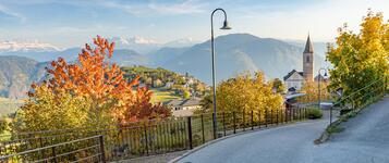
 Kurtatsch an der WeinstraßePhoto: Südtirols Süden
The Kurtatsch Farmsteads Trail is a varied circular walk that invites you to discover the history, culture and traditional way of life of the wine village of Kurtatsch. Following historic paths, the route passes old farmsteads, historic manor houses and lovingly maintained farmhouse gardens, leading through the picturesque vineyards of South Tyrol’s southern lowlands.
Along the way, you will encounter impressive reminders of the past that tell the story of the village and its inhabitants. Historic buildings and traditional farmsteads offer insights into rural life in bygone times and show how closely the development of Kurtatsch is linked to viticulture and agriculture.
A special feature of the trail is the QR codes located at selected buildings. They allow you to discover interesting information on site about the history of the farmsteads, their inhabitants and the architectural features of the historic buildings.
The route combines history, nature and the enjoyment of the local landscape. Between old stone walls, vineyards and idyllic paths, beautiful views of Kurtatsch and the surrounding southern lowlands open up time and again. The Farmsteads Trail is ideal for anyone wishing to discover the village away from the more familiar routes and immerse themselves in its history.
The circular walk starts in the village centre of Kurtatsch. From here, the trail leads through historic lanes and past traditional farmsteads and manor houses. Along the way, you can admire the characteristic architecture of the old buildings, lovingly maintained gardens and the typical rural landscape surrounding the village.
One of the highlights is Altlehen Manor, whose history dates back to 1259. Other historic farmsteads and buildings along the route invite you to discover Kurtatsch’s past step by step. QR codes provide fascinating background information directly on site.
The route then continues through the surrounding vineyards and along peaceful paths before returning to the starting point in the village centre.
Starting point: Village centre of Kurtatsch on the South Tyrolean Wine Road
Refreshment options: Restaurants, inns, cafés, traditional farm taverns and wineries in Kurtatsch offer inviting places to stop for refreshments before or after the walk.
The Kurtatsch Farmsteads Trail is a wonderful opportunity to discover the village’s historical heritage, winemaking traditions and distinctive landscape.
Südtirols Süden
Track types
Show elevation profileRoadbook
Starting point: Kurtatsch village centre
Route: The Farmstead Trail begins in the historic centre of Kurtatsch and follows a circular route through the wine village. The trail passes the village’s historic manor houses and farms before continuing uphill into the vineyards above Kurtatsch. It then leads through the surrounding cultural landscape, featuring traditional farm gardens and streams, before returning to the village centre. The complete village tour takes approximately 2 hours and can be shortened according to preference.
Refreshment stops along the route: Schwarzer Adler Restaurant, Kurtatsch Winery, Gasthof Terzer.
Highlights: Historic manor houses and farms, Altlehen Manor, Kurtatsch vineyards, historic village lanes, traditional farm gardens, streams and panoramic views over the South Tyrolean Lowlands.
Freienfeld Menhir
Rock formation live and in time-lapse video
The snake’s new clothes
Common wall lizards : Slim, nimble and poikilothermic
The smoke tree: Autumn colours as sun screen
Museum of People through Time
Church of St. Vigilius
Public transport
Kurtatsch on the South Tyrolean Wine Road can be reached by public bus from Tramin, Neumarkt, Auer and the surrounding villages. We recommend checking the latest timetables before setting off on your hike.Route 130: Kurtatsch bus station
Route 122 or 123: Kurtatsch Town Hall Square
Get Timetable to destination
Coordinates
Statistics


 Find accommodation