Hiking trail
· South of South Tyrol
Open
Leitenspitze (2027 m)
Responsible for this content
Südtirols Süden
Südtirols Süden
-
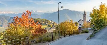
 Hiking paradisePhoto: Südtirols Süden
Selected alternatives for you
Scenic summit hike to Leitenspitze (2,027 m) in Trudner Horn Nature Park with alpine meadows, forests and panoramic Dolomite views.
Open
Difficult
Distance 18.8 km
6:57 h
1,039 m
1,039 m
2,024 m
985 m
This varied mountain hike takes you from Kaltenbrunn/Fontanefredde through the scenic forests and meadows of Radein/Redagno to the summit of Leitenspitze. Along the way, discover traditional mountain farms, peaceful woodland trails and spectacular views of the surrounding mountains.
The hike begins in Kaltenbrunn, where the trail initially leads through the forest before following the road towards Unterradein/Redagno di Sotto. Continuing uphill, you pass Troger farm before reaching Wastl and Zirmer farms in Oberradein/Redagno di Sopra. From here, the route leads past the village church and further into the valley towards Niggl farm, where a narrower hiking trail begins shortly afterwards.
The hike continues through varied woodland scenery and along forest tracks to Obere Kugelalm. From here, a steeper ascent leads up to Kugeljoch mountain pass. Passing below Kugelspitze, the trail eventually reaches the summit of Leitenspitze, rewarding you with magnificent panoramic views of the surrounding mountain ranges. Take a moment to relax and enjoy the breathtaking scenery and peaceful mountain atmosphere.
For the return journey, follow the Leitenweg trail along the western ridge, descending towards Unterradein. From there, the route continues back to Kaltenbrunn, bringing this scenic circular hike to a close.
The hike begins in Kaltenbrunn, where the trail initially leads through the forest before following the road towards Unterradein/Redagno di Sotto. Continuing uphill, you pass Troger farm before reaching Wastl and Zirmer farms in Oberradein/Redagno di Sopra. From here, the route leads past the village church and further into the valley towards Niggl farm, where a narrower hiking trail begins shortly afterwards.
The hike continues through varied woodland scenery and along forest tracks to Obere Kugelalm. From here, a steeper ascent leads up to Kugeljoch mountain pass. Passing below Kugelspitze, the trail eventually reaches the summit of Leitenspitze, rewarding you with magnificent panoramic views of the surrounding mountain ranges. Take a moment to relax and enjoy the breathtaking scenery and peaceful mountain atmosphere.
For the return journey, follow the Leitenweg trail along the western ridge, descending towards Unterradein. From there, the route continues back to Kaltenbrunn, bringing this scenic circular hike to a close.
Author’s recommendation
Early summer and autumn are ideal seasons for this hike. In autumn, golden larches and clear visibility create a particularly beautiful mountain experience.
Responsible for this content
Südtirols Süden
Südtirols Süden
Difficulty
Difficult
Overall difficulty
Difficult
Derived from the technical difficulty and the stamina requirements.
Experience
Landscape
Highest point
2,024 m
Lowest point
985 m
Best time of year
Jan
Feb
Mar
Apr
May
Jun
Jul
Aug
Sep
Oct
Nov
Dec
Track types
Show elevation profileRest stops
Ban MaxAlbergo Zirmerhof
Gasthaus Nigglhof
Pension Unterhauser
Safety information
The route enters alpine terrain and requires good fitness and sure-footedness. Fog or poor visibility can make orientation on the ridge more difficult.Roadbook
From Kaltenbrunn/Fontanefredde initially via a forest path, then along the road to Unterradein (nos. 7, 8, 9), up to Troger (no. 9) and on to Wastl Hof and Zirmer Hof in Oberradein, into the valley past the church of Oberradein to Nigglhof, after 100 metres turn onto the Jugendweg (ref. J), this leads into a forest path (ref. K), continue along this, then along a path in 2.5 hours to the Obere Kugelalm, steeply up to the Kugel Joch and past the Kugelspitze to the summit of the Leitenspitze (magnificent view). Descend via the Leitenweg along the west ridge (ref. K) down to Unterradein and then to Kaltenbrunn.
Rest stop
Nearby
Top Partner
Waypoint
Start point
End point
Low point
High point
Forecast
Today {low} to {high} and {precipitation} of {precipitation_type}
show {x} more
Photo
Video
Old RailwayBan Max
Albergo Zirmerhof
Library Radein/Radegno
Geomuseum Radein
Library Radein/Radegno
Geomuseum Radein
Geomuseum Radein
Geo Museo Redagno
St. Wolfgang Church Radein / Redagno
St. Wolfgang Church
E-bike rent GEOMuseum Redagno
Gasthaus Nigglhof
E-bike charging station Alpine hut Nigglhof
Charging station for electric vehicles - Radein
Isi hut
Baito Cugola Alta / Ob.Kugelalm
Pension Unterhauser
Public transport
Getting to the starting point of the tour or point of interest by public transport is easy and convenient.Get Timetable to destination
Leitenspitze (2027 m)
Directions
Take the A22 motorway and exit at Egna/Ora. Continue via Montagna and Trodena to Altrei. From Altrei follow the road towards Hornalm.Parking
Parking is available at Hornalm above Altrei.Coordinates
DD
46.330255, 11.375163
DMS
46°19'48.9"N 11°22'30.6"E
UTM
32T 682814 5133483
w3w
///flatland.reclamation.exulting
Get there by train, car, bike, or on foot!
Equipment
Sturdy hiking boots with good gripWeather-appropriate clothing
Warm additional layers
Plenty of drinking water
Sun protection
Hiking map or GPS device
Localization
Parts of this content were machine translated from German.
Status
Open
Difficulty
Difficult
Overall difficulty
Difficult
Derived from the technical difficulty and the stamina requirements.
Distance
18.8 km
Duration
6:57 h
Ascent
1,039 m
Descent
1,039 m
Highest point
2,024 m
Lowest point
985 m
Statistics
Maps and trails
Nothing selected - click and drag in the elevation profile to zoom
Distance
Duration
Ascent
Descent


 Find accommodation