Hiking trail
· South of South Tyrol
Open
Circular Hike in the Trudner Horn Nature Park
Responsible for this content
Südtirols Süden
Südtirols Süden
-
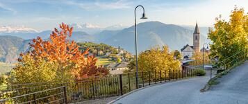
 hiking in the nature parc Monte CornoPhoto: Südtirols Süden
Selected alternatives for you
Hike from Truden to Krabes Alm via Rungganöhof, Peraschupf and Langes Moos. Through forests and natural landscapes, the route returns to Truden.
Open
Moderate
Distance 12.7 km
3:59 h
519 m
520 m
1,542 m
1,061 m
This scenic circular hike takes you from Truden through the peaceful forests and lush meadows of Trudner Horn Nature Park to the charming Krabes Alm mountain hut. Along the way, discover unspoilt natural landscapes, tranquil woodland trails and breathtaking views of the surrounding mountains.
The hike begins at the northern edge of Truden, where the trail follows the wooded slopes of Forchwaldegg towards Rungganö farm. From here, the route continues across open meadows and through shady forests to Peraschupf. On clear days, you can enjoy sweeping panoramic views across the Regglberg plateau towards the Texel Group and the Zillertal Alps.
Continuing through young woodland and past natural wetlands, the trail leads to Langes Moos before reaching Krabes Alm at 1,540 metres above sea level. Open during the summer months, this welcoming mountain hut is the perfect place to take a break, enjoy local specialities and soak up the peaceful alpine atmosphere.
From Krabes Alm, the route gently descends to Ziss-Sattel, a historic mountain pass connecting Truden and Altrei/Anterivo. The final stretch takes you through quiet spruce and fir forests before returning to Truden, bringing this varied circular hike to a close.
The hike begins at the northern edge of Truden, where the trail follows the wooded slopes of Forchwaldegg towards Rungganö farm. From here, the route continues across open meadows and through shady forests to Peraschupf. On clear days, you can enjoy sweeping panoramic views across the Regglberg plateau towards the Texel Group and the Zillertal Alps.
Continuing through young woodland and past natural wetlands, the trail leads to Langes Moos before reaching Krabes Alm at 1,540 metres above sea level. Open during the summer months, this welcoming mountain hut is the perfect place to take a break, enjoy local specialities and soak up the peaceful alpine atmosphere.
From Krabes Alm, the route gently descends to Ziss-Sattel, a historic mountain pass connecting Truden and Altrei/Anterivo. The final stretch takes you through quiet spruce and fir forests before returning to Truden, bringing this varied circular hike to a close.
Author’s recommendation
Take your time to discover the natural diversity of Trudner Horn Nature Park. The peaceful forest sections and viewpoints make this hike a special nature experience.
Responsible for this content
Südtirols Süden
Südtirols Süden
Difficulty
Moderate
Overall difficulty
Moderate
Derived from the technical difficulty and the stamina requirements.
Experience
Landscape
Highest point
1,542 m
Lowest point
1,061 m
Best time of year
Jan
Feb
Mar
Apr
May
Jun
Jul
Aug
Sep
Oct
Nov
Dec
Track types
Show elevation profileSafety information
The hike follows forest and hiking trails. Some sections can become slippery in wet conditions. Wear sturdy footwear and check the weather conditions.Roadbook
The hike starts in the village centre of Truden in the Nature Park. Follow the well-marked trails through the landscape of Trudner Horn Nature Park. The route passes through quiet forests, meadows and natural highlights of the area. Along the way, hikers can enjoy beautiful views of the surrounding mountains. Following forest paths and tracks, the circular route returns to the starting point in Truden.
Rest stop
Nearby
Top Partner
Waypoint
Start point
End point
Low point
High point
Forecast
Today {low} to {high} and {precipitation} of {precipitation_type}
show {x} more
Photo
Video
Charge E-Car in Truden i.N.Drinking water fountain Truden i.N. Dorfeingang
Krabes Alm
Drinking water fountain Truden i.N. Kneippanlage
Kirchenchor "St. Blasius" Truden
Drinking water fountain Truden i.N. Sägeweg
Parish Church San Biagio
Drinking water fountain Truden i.N. Kirchplatz
600 years old lime ain Truden i.N.
Charge E-Car Truden i.N.
Monte Corno Nature Park visitor centre
drinking water fountain Kajetan Pacher Str. Truden i.N.
Public transport
Take the train to Neumarkt/Auer. From there, bus connections are available to Truden. Current connections can be checked via Südtirolmobil.Get Timetable to destination
Circular Hike in the Trudner Horn Nature Park
Directions
Take the A22 motorway and exit at Neumarkt/Auer. Continue via Montan and Kaltenbrunn to Truden in the Nature Park.Parking
Public parking is available in the village centre of Truden in the Nature Park.Coordinates
DD
46.323501, 11.351531
DMS
46°19'24.6"N 11°21'05.5"E
UTM
32T 681018 5132679
w3w
///humbles.flooding.page
Get there by train, car, bike, or on foot!
Equipment
Hiking boots with good grip, weather-appropriate clothing, sun protection, sufficient water and hiking poles if required.Status
Open
Difficulty
Moderate
Overall difficulty
Moderate
Derived from the technical difficulty and the stamina requirements.
Distance
12.7 km
Duration
3:59 h
Ascent
519 m
Descent
520 m
Highest point
1,542 m
Lowest point
1,061 m
Statistics
Maps and trails
Nothing selected - click and drag in the elevation profile to zoom
Distance
Duration
Ascent
Descent


 Find accommodation